


Geographic Information System (GIS)
Powering smart utility decisions through modern geospatial intelligence
We help electric utilities modernize how they understand, plan, and manage the grid through advanced GIS technology and data-driven solutions.
Our Geographic Information System (GIS) professionals deliver end-to-end solutions that help organizations transform geospatial data into actionable insights, improved operations, and streamlined reporting.
We combine power systems engineering expertise, advanced GIS capabilities, and your organization’s institutional knowledge to deliver:
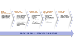
- GIS strategy, planning, and implementation
- Data assessment, preparation, and quality assurance
- Data conversion, integration, and migration
- Pilot development, testing, and validation
- Training and technical documentation
- GIS staff augmentation and specialized technical support
Our GIS capabilities include:
- Full-stack web-based User Interface design, development, and deployment
- Data digitization and conversion
- Georeferencing
- Geocoding and reverse geocoding
- Data quality assurance and quality control (QA/QC)
- Professional mapping and geospatial visualization
- Population and demographic analysis
- Growth and development analysis

Why Danovo Energy Solutions?
Our experienced GIS professionals work closely with power systems engineers, uniquely positioning us to help utilities identify capability gaps, strengthen data strategies, and enhance planning and operations across transmission and distribution systems. Through advanced spatial analysis, visualization, and reporting, we also help utilities prioritize and justify capital investments. Integrating GIS across utility functions improves decision-making, strengthens operational performance, and delivers measurable value throughout the organization.
Contact us to learn more about GIS